 At an altitude of 2,857m, Mount Jonen (常念岳) is one the highest peaks in all of the Northern Alpine range and overlooks the vast majority of Azumino as well as the neighbouring Kamikochi area. Having lived in Jonen’s shadow for the best part of the last three years, I finally decided to make a go of hiking this magnificent mountain by conscripting the company of my good friend and Japanese mountain-expert, Brian, and making a 2-day camping trip of it with the hope of taking in the Azumino sunset and sunrise.
 Getting up to the base of Jonen can be tricky without a car, but taxis in the area often take hikers up to the parking area, which is about 5 minutes walk from the hike’s starting point. As we were intending to camp near Jonen’s summit, we started the hike just after lunch and passed several hikers making their descent along the way. The first part of the hike is perhaps the most challenging as it involves a rather steep ascent up a forest trail. After about a 700m climb, the trail became more manageable and we found ourselves overlooking a spectacular panorama of the surrounding mountainside as well as the valley below.
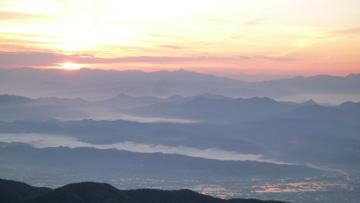
 After getting to Mae-Jonen, a resting-point about 200m below the peak, we set-up our tent in a small but comfortable mountain hut that was to protect us from the freezing mountain winds and serve as a vantage point for watching the sunset that evening, as well as the sunrise the next morning. As we had hoped, the views failed to disappoint, and we were treated to one of the most beautiful scenes that can be found in Japan – even spotting Mount Fuji in the far horizon!
Details: Trail head begins at Ichi-no-sawa (beware: there is an alternate hiking route that begins at Mitsumata and is much more difficult) which is about 20 minutes by car/taxi from Hotaka train station. (From Matsumoto, north to Hotaka, it takes about 30 minutes by car or train.)
From the trailhead (restrooms, drinking water, shelter) the route follows a beautiful mountain stream as it gradually narrows; the trail gets steeper, then the final hour is mostly switchbacks leading to the saddle where the lodge is located. Trailhead to lodge is about 3.5 to 4.5 hours, then another hour (steep) to the summit. Hikers are advised to allow some time at the top as it is one of the most beautiful vistas in the Japanese Alps.


Hey Alex. Is the trail well marked along the way and is it sign-posted in English? And how do you get back Hotaka train station? eg: hitch? I’ve done lots of hiking about 10 years ago and would love to do this as an overnight hike, staying at the lodge. Any info would be greatly appreciated. Your pix are awesome. Tks so much. Lisa
Hi Lisa,
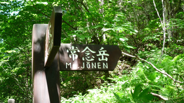
The trail is fairly well marked in English along the way (as you can see in the first picture) and there is a detailed map at the trail head that clearly delineates your route, but as always, it wouldn\’t hurt buying a hiking map in advance! Please note though that unless you have winter gear and requisite experience in snowy conditions, it\’s only advisable to do the trail between late April and early November.
As for transport, getting to trail head is easy by taxi from Toyoshina or Hotaka train stations but getting back may be tricky as (from what I can remember from 18 months ago) there is no public service running from the trail head. While there are plenty of friendly hikers with cars that frequent the trail and would no doubt happily take hitch-hikers, a safer bet would be to take a cell phone and call a local taxi service when you are done. Details of local taxi companies can be found on the \’Local Transportation\’ tab on the left sidebar of this page.
Alternatively, there is a great trail to the summit of Mount Tsubakuro that can taken with a local bus service that runs from a trail head starting at Nakabuse Onsen, about 20-30 minutes bus ride from Hotaka Station. Details can again be found on the \’Local Transportation\’ page.
Hope that helps and happy hiking!
Alex
Thanks for your nice page on Jonen-dake. Just a short note that I climbed this peak in Aug. of last year, and when I got back to the Ichinosawa trailhead, there was no service available on my NTT Docomo cell phone, so I had to hitch out with a couple of delightful middle-aged lady hikers.
Hi,
What would this hike be like in mid May? Would it be too dangerous due to snow and ice? It sounds fantastic! Would really love to do it, but we\’re there in May and are concerned it might not be possible to do. It\’s been a bit hard to get a definite answer on the internet. Any help would be great!
Thanks!
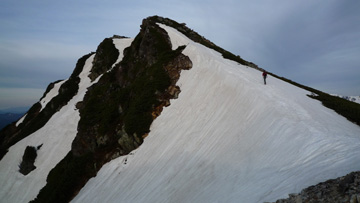
There will be snow remaining on some trails (see photos of personal blogs like http://mami0828.blog57.fc2.com/blog-entry-363.html and http://yama.mogudesu.com/?eid=1294160 some Japanese wrote after they climbe mid-May). If the weather is good and you have exprience and gear for walking on frozen snow, it is possible and will become fantastic exprience. Take care!
Hi Alex, thank you very much for the good info. I planned the hike in July and would like to start at Mitsumata. What makes it so much more difficult? Do not have that big experience but at least climbed some other mountains (e.g. Mt. Minami dake) without any problem. Looking forward to your feedback. Best regards. Henning
Hi, Henning
Alex has left Japan four years ago and now lives in UK.
The reason Mitsumata root is difficult is it is more steep and you need more stamina, skill, and preparation (drink, food, clothes, etc). Sometimes accident happens in the root.
Take care!
Thank you very much for your feedback matadm. Very much appreciated. We intend to hike in a round from Mitsumata to Mt. Jonen on the first day, next day to Mt. Chogatake and on day 3 back to Mitsumata. We come by car and would like to leave it at Mitsumata. The Ichinosawa mountain stream is just far away from Mitsumata … maybe we think about it again. Thank you very much again.